Welcome to the AZG&T Saguaro-Marana 115/138kV Transmission Line Project Virtual Open House!

We appreciate your interest in the Project and look forward to incorporating your feedback into the planning process.

As you scroll down this page, you’ll be able to review the subject matter stations that would be provided at an in-person project open house.

At any point during the Virtual Open House feel free to click on the “Contact Us” menu link at the top of the page. There you can submit feedback or reach out directly to the project team to provide your questions and contact information so that we can respond to your inquiry.

Scroll Down to Enter the Open House!

Station One: Project Purpose and Need

Arizona Electric Power Cooperative, Inc. (AEPCO) and Tucson Electric Power (TEP) are planning new electrical infrastructure to serve the town of Marana, Arizona and the surrounding area.

The Saguaro to Marana Project planning process is being conducted for AEPCO to construct a new 115 kilovolt (kV) transmission line between the planned Trico Electric Cooperative Inc. Adonis Substation and the existing Marana Substation. The Project will connect to the existing Saguaro Substation located approximately 7 miles northwest of Marana using an existing transmission line. TEP has identified the need for a new 138kV substation within the town of Marana. TEP will need a 138kV transmission line to provide power to this substation.

The Project will increase electric reliability and serve customers’ growing energy needs, as well as add transmission
capacity to support the development of future energy generation projects.

Project Map

Energy 101

In today’s world, electricity is manufactured in many ways, from large-scale remote power plants all the way to local small-scale renewable energy sources. However, the bulk of electricity, no matter where it is generated, travels over long distances through a system of transmission and distribution lines that carry the electricity to where it is needed and substations that convert the voltage to an amount usable by a specific customer. This diagram gives an approximation of the path that electricity takes between where it is manufactured and a typical customer. This project primarily consists of siting new 115kV transmission lines shown circled in blue on the diagrams below.

Power 101

Project Features

Steel monopole (single pole) structures are typically used for new 115kV transmission lines but may include a variety of structure types, ranging in height from approximately 65 feet to 95 feet tall depending on routing, terrain, and crossing of existing structures, including elevated roads, riverbeds, and other transmission lines. The typical rights-of-way or easements will be approximately 100 to 120 feet wide. Any opportunity to utilize existing transmission line routes for the new 115kV structures will be considered.

Proposed Transmission Structure

Typical Transmission Structure

Project Schedule

AEPCO has been evaluating the need for this project for the last 18 months. There have been several engineering and environmental technical studies completed for the project to determine the type of facilities needed and the general area where the facilities will be located. The planning process being conducted now will take approximately 6 to 12 months and will be completed in sequential steps as illustrated in the schedule diagram below.

Project Schedule

Up Next: Planning Process

Station Two: Planning Process

AEPCO considers several factors in detail prior to making decisions related to constructing and operating new transmission lines and substations. There are detailed engineering and environmental studies that are completed during the planning process. Throughout the planning process, AEPCO will also collect input from key agencies and the public (e.g., landowners, residents, business owners, etc.) prior to selecting final locations for the proposed facilities. The information provided below will help the community understand the important data that will be evaluated during the planning process.

Planning Process Diagram

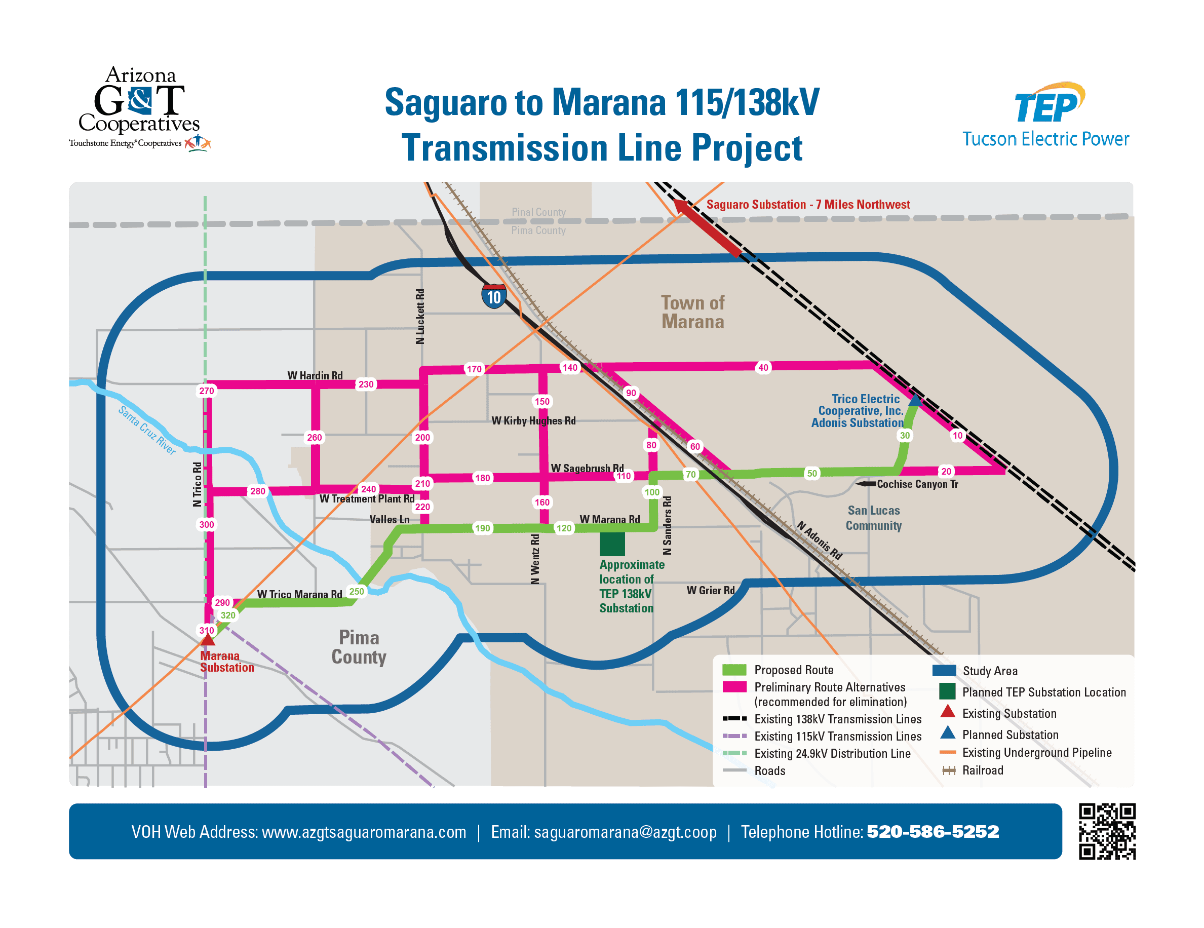
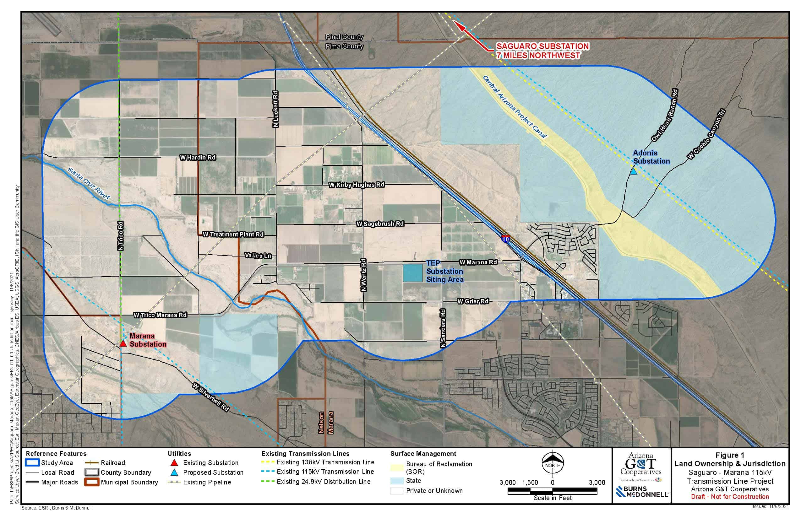
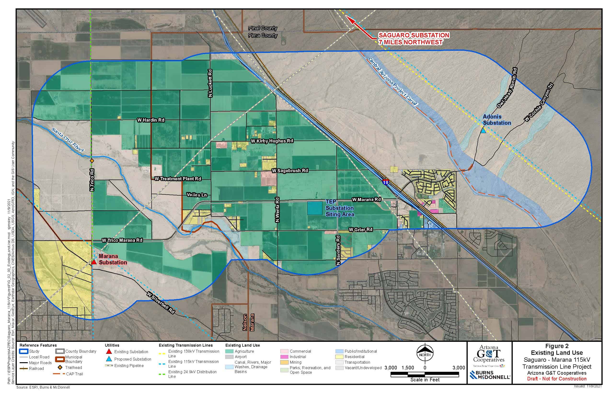
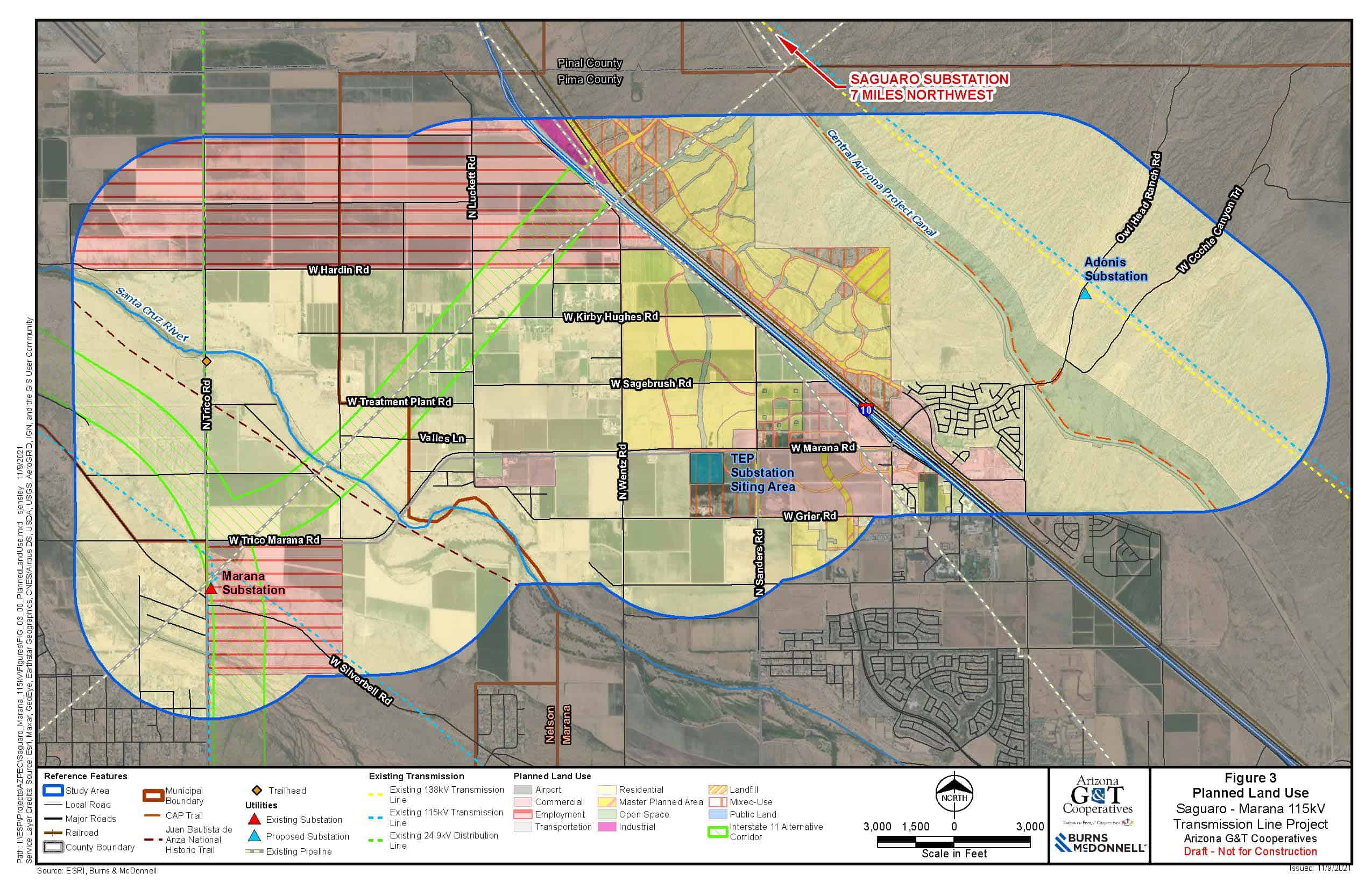
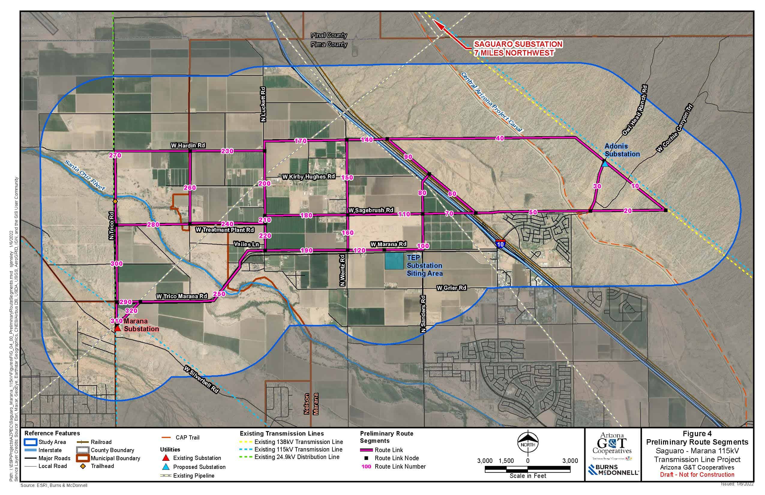
Land Ownership and Jurisdiction

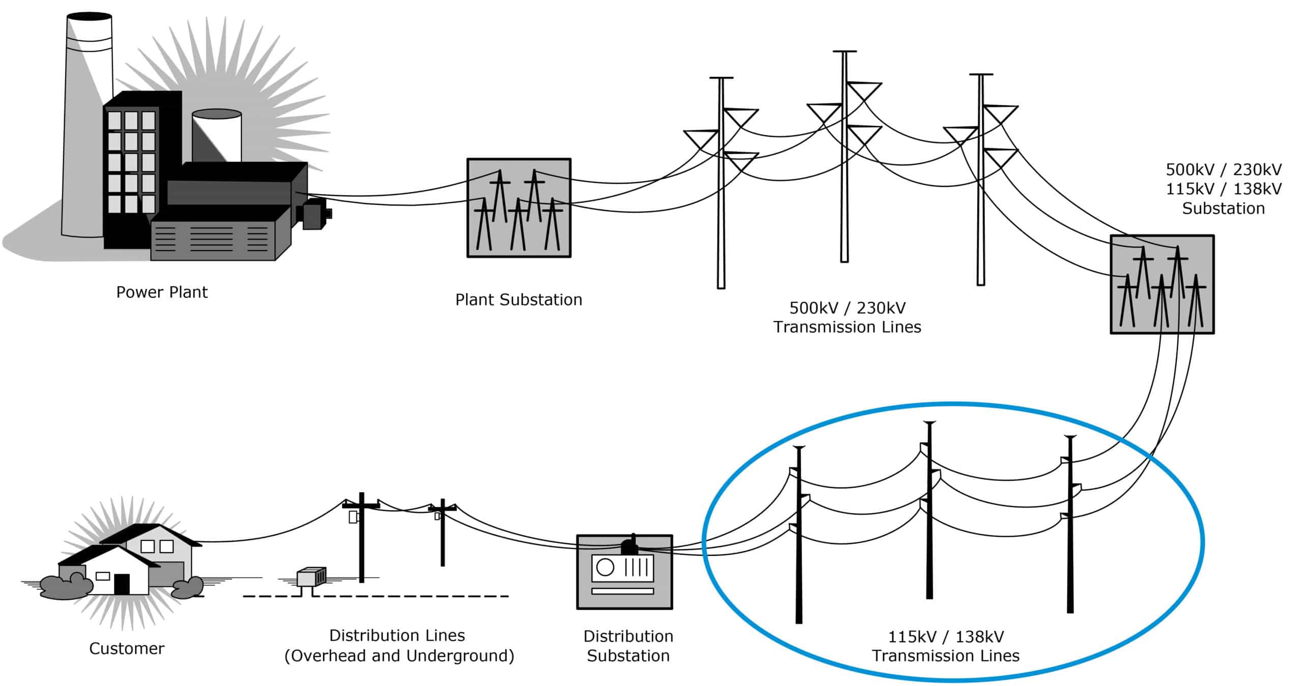
To determine the criteria locations, we first identified the landowners, jurisdictions, and agencies within the Project study area to determine existing and planned land use and jurisdictional planning guidelines. Cities, towns, and counties in the study area typically have long-term plans that consider potential expansion of their current jurisdictional boundaries. These broader jurisdictional planning areas are reflected in officially adopted General Plans or Comprehensive Plans and identify desired future land use plans including residential, commercial, industrial, recreations, educational, etc. uses that are to be considered for development within the community. These jurisdictional planning areas are important to consider when planning new electrical infrastructure such as the proposed 115kV transmission lines. The following map shows the land ownership and jurisdictional boundaries within the study area.

Project Jurisdiction Map

Siting Criteria

Multiple studies have been conducted to help us identify areas that better lend themselves to accommodate this transmission line (opportunities), and locations that would be less accommodating for the transmission line (constraints). The criteria shown in the Opportunities and Constraints chart helps us identify route opportunities for the construction, operation, and maintenance of the new 115kV transmission lines and minimize impacts of the line to residences or other sensitive areas. For example, an arterial roadway would be considered a high-ranking opportunity to locate the new transmission line. However, that same arterial road would rank lower in a residential community (an area of high constraint) than it would within a commercial zone (an area of moderate constraint). The criteria used in identifying locations of opportunity and constraints include the following:

Table 1

Table 2

Table 3

Existing Land Use

Land use information provided to us by the various agencies and jurisdictions allowed us to create the Existing Land Use map below to help us further determine current areas of opportunities and constraints.

Existing Land Use

Planned Land Use

Information regarding planned land use was also provided to help us determine the best locations for our facilities as shown in the Planned Land Use map below.

Planned Land Use

Up Next: Route Alternatives

Station Three: Route Alternatives

Opportunities and Constraints

Existing and planned land use and visual resources data were used to identify areas that are most suitable for construction of the proposed 115kV transmission lines. The map below illustrates a composite of all the opportunities and constraints within the Project study area. Opportunity areas including following existing transmission lines and major roadways are shown in blue. Areas with low sensitivity including industrial or undeveloped areas are shown in green, areas with moderate sensitivity such as commercial areas or business parks are shown in yellow, and areas with high sensitivity such as residential areas are shown in red. This initial analysis helped determine:

  • Locations that minimize impacts to sensitive resource areas (e.g., existing residences, schools, etc.)
  • Locations that maximize the use of existing siting opportunities (e.g., existing transmission lines, roads, canals, etc.)

Opportunities and Constraints

Alternative Routes

The opportunity alignments along existing transmission lines and major roadways were evaluated with respect to the constraints associated with the underlying existing and planned land uses to identify preliminary alternatives for routing the proposed transmission lines. Additional siting considerations including constructability, engineering, and other technical factors were also evaluated. This map shows several preliminary alternative links that could be used to create routes that will connect the substations needed to serve customers. During the planning process, preliminary alternative links were considered, and a proposed route is being advanced based upon the route study and comments received from agencies and the public.

Preliminary Route Segments

Proposed Route

AEPCO has identified a proposed route from the options shown on the map above. You can view the proposed route on the map below as well as the Interactive Map.

The following Interactive Map uses geographic information system (GIS) technology to allow the agencies and public to view the project interactively. The proposed route, each of the previously considered preliminary alternative links, and the study area can be viewed on aerial imagery illustrating the existing landscape in the area. Please note, all alternatives and the proposed route are only conceptual and do not represent final locations or design.

Project Map

Visual Simulations

Visual Simulation 1A

Visual Simulation 1B

Visual Simulation 2

Siting Considerations

When siting new electrical facilities, AEPCO strives to:

  • Minimize impacts to sensitive resource areas, including residential developments, cultural sites, wildlife and avian habitat, airports, etc.; and
  • Maximize use of siting opportunities, including locating near existing linear features and/or compatible land uses such as transmission lines, roads, canals, substations, etc.

Numerous considerations are in play when siting electrical facilities, as identified below.

Siting Considerations

Up Next: Agency and Public Outreach

Station Four: Agency and Public Outreach

AEPCO has been conducting extensive agency and public outreach for all of its major transmission line and substation projects for more than two decades. Input from the agencies and public is critical to the success of each new project we propose to construct and operate to serve our customers. There is additional information on the FAQ page. You are welcome to contact the project team with any comments and questions using the “Contact Us” button below.

If you’d like this information to go, use the link below to download and print our project newsletter or postcard.

If you would like to contact us via email or telephone, please use the following information.

Email: [email protected]

Message Hotline: (520) 586-5252